Cycle and Ebike Insurance
Explore the great outdoors on two-wheels, knowing that Bikmo’s cycle insurance has got you covered.
View Cycle and Ebike InsuranceJonathan Manning enjoys breathtaking views as he follows an old railway line through wondrous Peak District countryside
Imagine if every closed railway line had been repurposed as a track for walkers and cyclists. The UK would have been criss-crossed by a network of level, traffic-free routes connecting places people wanted to travel between – just not enough people to make a business case for keeping the trains running.
The Peak District showcases what these trails would have been like. The Monsal Trail, Tissington Trail and High Peak Trail all once echoed to the whistle of steam engines and now welcome lovers of the outdoors.
This ride, from Buxton Club Campsite, picks up the start of the High Peak Trail and could lead as far as Cromford in the Derwent Valley. Alternatively, a ‘branch line’ offers a route to Hartington and Ashbourne along the Tissington Trail.
Cyclists with the spirit of Forrest Gump could even continue along the Pennine Bridleway, and pedal for almost 200 miles along old lanes, pack horse routes and drovers’ roads to Cumbria.
At just over 20 miles out and back, this ride has more modest aspirations, but its original intention of being an easy, flat railway ride are undermined by the gradient profile of the section before it joins the High Peak Trail. The good news is that this uphill effort is rewarded by breathtaking views over a White Peak landscape of grazing pastures, drystone walls and angular hills, before the level, gravel trail takes over.
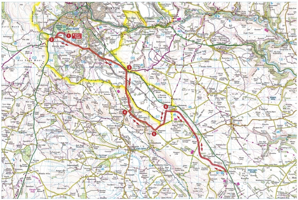
1. From Buxton Club Campsite cycle through the country park to reach Grin Low Road. Turn left and continue to a T-junction.
2. 2.9km – Turn right at the T-junction by The Parks Inn, signposted to Longnor. Continue for about 2.5km to reach a T-junction opposite High Peak Bookstore.
3. 5.6km – Turn right at the T-junction, and start a long uphill climb, passing a quarry on the left. When the road starts to head downhill, look out for the first turn on the left, with a slightly obscured sign to Earl Sterndale and Crowdecote.
4. 7.8km – Turn left to Earl Sterndale and Crowdecote and ride into Earl Sterndale. Immediately after passing the church on the left, take the next left turn, with a green on the right. Continue to a T-junction. Turn left at the junction, signposted to Crowdecote, Pilsbury and Hartington. In 200m, before reaching the village pond on the right, turn left. Continue for just over 1km, looking for a turn on the left.
5. 10km – Take the left turn along National Cycle Network 68, opposite Wheeldon Trees Cottages. Continue for 800m, then turn left along the white gravel track (NCN 68). In 800m look out for a turn on the right.
6. 11.6km – Turn right along the Pennine Bridleway to Parsley Hay. Continue for 5.5km, soon joining the High Peak Trail, to reach Parsley Hay, where refreshments are available. This route then U-turns to retrace its steps back to the Club site. However, for riders who want to go further, in 450m the High Peak Trail continues along the left fork to Cromford (22.4km farther), while the right fork becomes the Tissington Trail and heads via Hartington to Ashbourne (23km farther). Both options require a U-turn to head back along the same route to the Club campsite.
You can download this route from our dedicated Strava page here.