Cycle route from Warwick Racecourse Club Campsite
Jonathan Manning marvels at the magnificent Hatton Locks on this gentle canalside ride
The vision, commitment and willingness to take financial risk among Industrial Revolution entrepreneurs is mind-blowing, and has left a sublime network of transport links for cyclists to enjoy.
Canals connected towns and cities, shipping raw materials to factories and carrying finished goods to customers, in weights and volumes that horses and carts couldn’t hope to match. And when canal transport was considered too slow, entrepreneurs put their cash into railways to provide quicker deliveries to and from Britain’s manufacturing heartlands.
The waterways have long ceased to be corridors of trade, and Dr Beeching closed many of the railways, but their respective towpaths and track beds have become cherished trails for bike riders.
The first half of this route from Warwick Racecourse Club Campsite heads out through the Shakespearean countryside of Warwickshire, dotted with the occasional Tudor-style house and villages with names such as Norton Curlieu.
At its halfway point, it crosses over the M40 motorway, which runs in parallel with a railway line, before joining the Grand Union Canal – the slow, medium and fast of today’s travel and transport. The canal stretches 137 miles from London to Birmingham and was dug to transport coal to the power stations and factories of the Black Country.
At Hatton, the canal confronted the contours of a hill, so engineers built 21 locks in quick succession to speed the barges and narrow boats on their way. It apparently takes about five hours to pass through this so-called ‘stairway to heaven’, which makes a great spot to buy a coffee at the café and watch the world drift by.
The full length of the towpath is blissfully quiet and rich in wildlife, but it’s also narrow and muddy in places, so best ridden at ‘off-peak’ times.
Directions
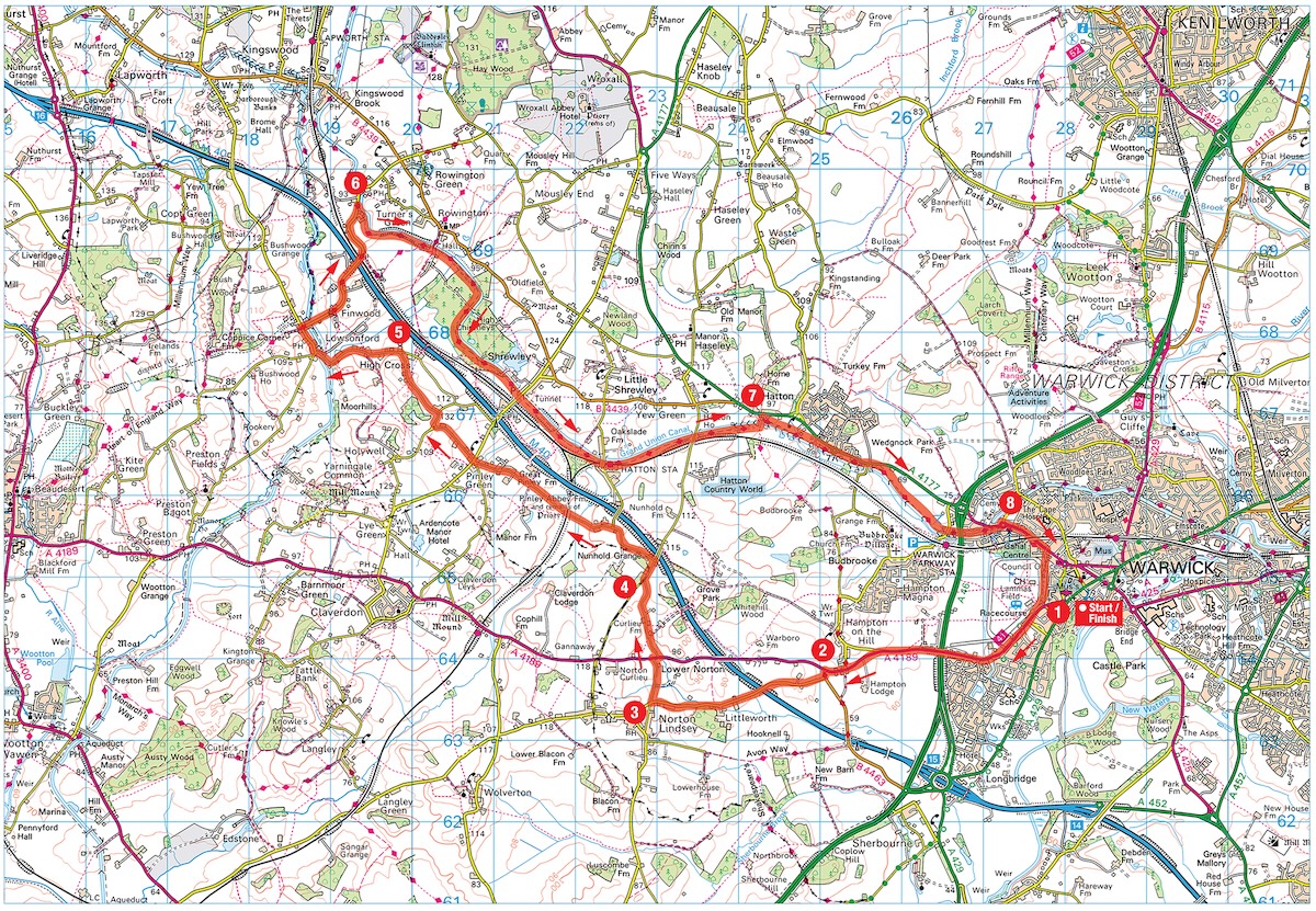
1. From Warwick Racecourse Club Campsite, cross the race track and continue to a T-junction. Turn right along Hampton Street, and continue for 3km, before looking for a turn on the left.
2. 3.1km – Turn left to M40 and Coventry, then almost immediately turn right to Bearley and Norton Linsey.
3. 5.5km – Turn right in Norton Linsey along Brittons Lane, signposted to Hatton. Continue to a T-junction with the A4189, turn right, then left almost immediately along Norton Curlieu Lane. Continue to a T-junction.
4. 7.1km – Turn right to Hatton, then take the next left to Pinley and Hatton Station (if you reach the M40 you have gone too far). Go straight across the crossroads in Pinley Green, signposted to Lowsonford and Holywell, and continue to a T-junction.
5. 11.8km – Turn left at the junction to Lowsonford, cross the Stratford-upon- Avon canal, pass the Fleur de Lys pub, and take the next right (Mill Lane), signposted to Rowington and Coventry. Continue to a bridge in Turner’s Green, with the Tom o’ the Wood pub on the far side.
6. 15.4km – Do not cross the bridge, but turn right before it, descending the slope to the towpath of the Grand Union Canal. Turn right, with the canal on the left. At the Shrewley Tunnel, climb the steps, cross straight over the road, and continue back to the canal (still on your left). Continue to Hatton Locks.
7. 22.7km – Turn left over the bridge at Hatton Locks, then immediately right along the towpath, so the canal is now on your right. Keep going for about 3.5km until bridge 51 (1992). Go under the bridge then turn left immediately up the steps to reach a road.
8. 26km – Turn left at the road and follow the cycle path, then the road, passing under a railway bridge. At the traffic lights next to The Antelope pub, turn right into Vittle Drive. Continue through the car park, with the racecourse on the right, to reach the right turn back to the Club campsite
You can download this route from our dedicated Strava page here.
About the route
- Start/finish: Warwick Racecourse Club Campsite, Hampton St, Warwick CV34 6HN.
- Distance: 27.6km/17.25m.
- Time: 3 hours.
- Level: Suitable for all cyclists – the towpath is narrow in places, and there is some riding on busier roads at the start and end.
- Terrain: Road, gravel and mud tracks. Mountain, hybrid or gravel bikes needed.
- Landscape: Pretty countryside and villages, woodland, and Grand Union Canal.
- Refreshments: Fleur de Lys pub, Lowsonford; café at Hatton Locks.
The Caravan and Motorhome Club make no warranties concerning the accuracy or completeness of the routes published, which to the best of our knowledge were correct at the time of publication. Your use of the routes is at your own risk and we accept no responsibility for the suitability or safety of any routes published. Routes may be out of date or affected by changes to the physical environment and, to the extent permitted by law, we accept no responsibility for personal injury or property damage caused by your use of the routes.
About the author