Meathop Fell
Cottage or apartments in Grange-over-Sands, Cumbria
Choose from a range of apartments or a homely cottage in the pretty Grange-over-Sands
View Meathop Fell cottagesMark Sutcliffe explores a fascinating landscape where the foothills of the Lakeland fells meet the vast skyscapes of Morecambe Bay

This quiet corner of the Lake District, where the foothills of the high fells meet the coastline of Morecambe Bay is an often-overlooked landscape where nature is making a real comeback.
Thanks to sympathetic management by Cumbria Wildlife Trust, which is carefully restoring the wetlands along this coastal strip, rare species such as the osprey, green hairstreak butterfly and a host of dragonflies are returning to this expanse of raised peatbog – one of England’s scarcest habitats.
This walk from Meathop Fell Club Campsite follows the River Winster into the woodlands flanking the prominent limestone cliffs of Whitbarrow Scar, passing the elegant Halecat House, with its beautiful gardens and Grade II-listed gazebo, before returning to Meathop Fell Club Campsite across Meathop Moss.
I followed this route on a gloriously crisp winter’s morning, flushing snipe and woodcock from the mossland and watching stonechats feeding among the seedheads of the reeds. But the mosses really come alive in late spring and summer, when the ospreys return to neighbouring Foulshaw Moss to nest and the reserves hum with the sound of insects making the most of the summer warmth.
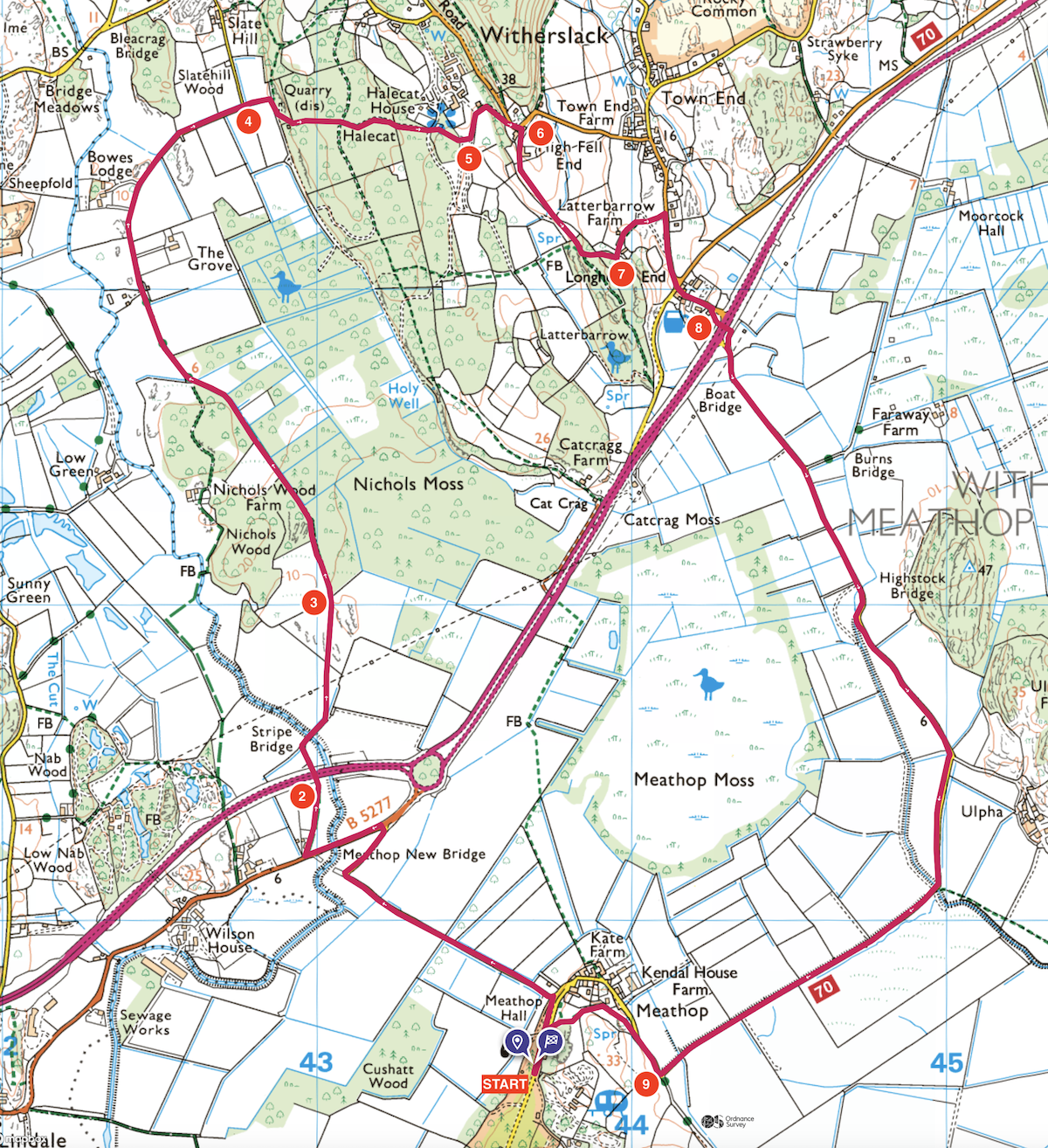
1. From the site’s main gate, turn right along the access road and continue past some houses, turning left at a postbox onto a lane. Continue along the lane for half a mile to the junction. Follow the road left across the bridge then take the bridleway through a gate on the right, across a field then through another gate to the main road.
2. 1.6km – Cross the dual carriageway with care, then continue along a bridleway, heading right over a footbridge, then slightly left through a gate to skirt left of the rocky outcrops and through a gate into the woodlands of Nichols Moss.
3. 2.3km – Follow the bridleway through the stands of holly, birch and Scots pine to reach another bridleway joining from the left. Continue slightly right on a gravel track, past farmhouses, following the track as it arcs around to the right and becomes a lane.
4. 4.2km – Where the lane swings left, continue straight ahead towards the woods. Follow the track round to the right, then veer almost immediately left on a narrow footpath into the woods. Climb steeply through the woods and where the gradient levels out, continue straight ahead over a junction of paths and descend on a gravel track to the nursery at Halecat House.
5. 5km – At a junction, head left then immediately right through a kissing gate and continue past a gazebo and through a gate, passing Halecat House. At the next footpath junction, head left, climbing steadily, then right, past some stables and climb through the woods to a lane. Continue on the lane then turn sharp right onto a rocky track.
6. 5.2km – Descend gently past some cottages and continue through a gate and straight on across a field to another gate in the bottom left-hand corner of the field. Go through the gate, continue to the second path junction and fork left, climbing briefly to cross a stone stile at the edge of the woods.
7. 5.8km – Continue along the left-hand wall then left through a gate and past some cottages, following the track to a footpath on the right leading into a village. Go over the stone stile, turn right and continue down a lane to the Derby Arms. Continue straight over the crossroads, signposted Grange and Ulpha.
8. 6.3km – Before reaching the main road, veer right to head under the carriageway using the cyclist and pedestrian tunnel. Beyond the tunnel, follow the path right to join a lane and continue along the lane, following the route of National Cycleway 70 as it arcs back across the moss to join the Cumbria Coastal Way towards Meathop .
9. 9.7km – At a junction at the edge of the moss, turn right then take a footpath on the left after 150 yards and follow it as it curves left and over a stile then right to join a lane. Turn left to return to the site gate.
Download this route and others to your smartphone or GPS device from the Club’s OutdoorActive page at: out.ac/IPp3bt